Body
1-second aerosol extinction and absorption measurements from the SOAP instrument during the 2018 ATom-4 campaign.

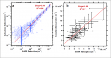
Figure 1. (a) Aerosol extinction calculated using Mie theory from composition-resolved size distributions plotted as a function of measured extinction from the SOAP cavity ring-down spectrometer during the ATom-4 campaign, showing representative error bars. (b) Calculated aerosol absorption and measured absorption from the SOAP photoacoustic spectrometer for cases when absorption >2 *10-6 m-1 (2x the detection limit).
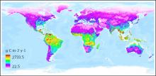
Mean global soil respiration derived from Version 5 of the Soil Respiration Database (SRDB-V5).
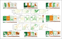
The sums of seasonal mean SMUrF-based NEE and ODIAC-based FFCO2 for CONUS (a), western Europe (b), and East Asia (c) for 2018 in centered panels. City-wide GEE, Reco, NEE, and FFCO2 over JJA 2018 are provided around the centered panels.
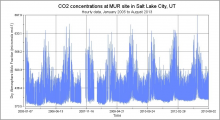
Carbon dioxide concentrations at the MUR site in Salt Lake City, Utah, show a pronounced seasonal pattern of higher CO2 in the winter months.

Logo of the Global Ecosystem Dynamics Investigation (GEDI) mission.
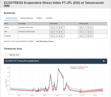
Fixed Site Subset screen shot for the Tumanrasset INM site in Algeria of the AERONET and BSRN networks.
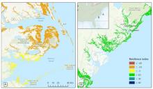
Contrasting levels of resilience of tidal marshes to sea-level rise in eastern North Carolina (A) and coastal South Carolina (B).
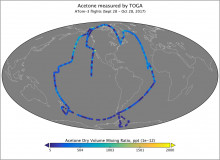
Measurements of atmospheric acetone concentration from samples collected by the Trace Organic Gas Analyzer (TOGA) during ATom-3 flights in 2017.
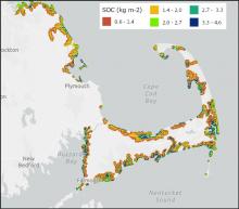
Predicted soil organic carbon (SOC) content of wetlands at 0-5 cm depth in the vicinity of Cape Cod, Massachusetts, U.S. Estimates represent the period 1998-2018 and were derived from publicly available data sources using a quantile regression forest model.
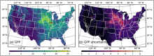
Spatial distribution of (a) GPP (gC m2/d) and (b) GPP uncertainty (gC m2/d) across CONUS at 250-m resolution for 10 July 2020