Body
Measurements from the Meteorological Measurement System (MMS) instrument from the four ATom campaigns.

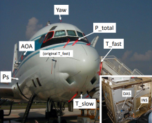
MMS instrumentation on the DC-8 aircraft during the fourth field campaign in the NASA Convection and Moisture Experiment (CAMEX) series.
Aerosol extinction across ATom campaigns. Sea salt is shown in (g) and (h), dust in (i) and (j), and water in (k) and (l). Source: Brock et al., 2021
Delta-X is a 5-year NASA EVS-3 mission to study the Mississippi River Delta in the United States, which is growing and sinking in different areas.
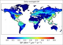
Predicted spatially contiguous SIF in the first half of August 2015. The highest SIF values during this time period were observed in agricultural sectors in the Northern Hemisphere. Source: Data file sif_ann_201508a.nc
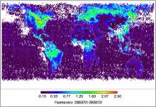
Gridded SIF estimates derived from the L2 SCIAMACHY SIF dataset at 1-degree resolution for July, 2005.
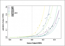
Site-specific soil moisture sensor calibration curves. Laboratory determined volumetric water content (VWC) is plotted against the raw VWC sensor output
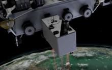
The Global Ecosystem Dynamics Investigation (GEDI) instrument provides high resolution laser ranging of Earth's forests and topography from the International Space Station (ISS).
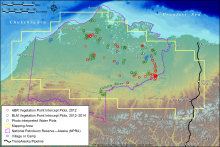
Map of quantitative-cover mapping area showing the distribution of field plots, North Slope, Alaska. Source: Macander et al., 2017
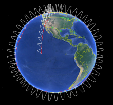
Generalized overview of ATom flights.
The Claes Fornell International (CFI) Group has concluded feedback solicitation on behalf of NASA for EOSDIS DAACs to determine customer satisfaction in 2022.