Body
An update to a dataset that characterizes the global distribution, biomass, and canopy height of mangrove-forested wetlands based on remotely sensed and field measurements.

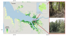
Globally the tallest mangrove forests in coastal Gabon are estimated up to 63 m. The photo insets show locations where individual trees were measured in situ up to 65 m tall (Simard et al., 2019).
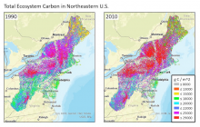
Estimated total ecosystem carbon for the northeast region of the U.S. for the years 1990 (left) and 2010 (right). The estimates were produced from an inventory-constrained version of the Carnegie-Ames-Stanford Approach (CASA) carbon cycle process model.
Optics of Photosynthesis Laboratory Logo
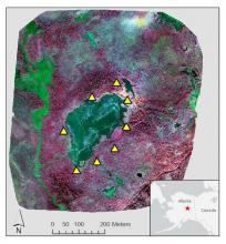
Color infrared image of Big Trail Lake in the Goldstream Creek Valley north of Fairbanks, Alaska. Ground control points (yellow triangles) surround the lake. Image was produced from NIR (red), red (green), and green (blue).
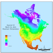
Daymet V4 maximum daily temperature shown for March 31, 2021.
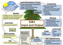
Overview of the Simple Biosphere Model (SiB4) that estimates carbon fluxes among the atmosphere, vegetation, and soils. Input information is shown in yellow boxes. These datasets include a selection of the output variables (blue boxes). Source: Haynes et al. (2020)
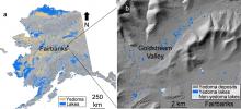
Location of the study area northwest of Fairbanks, AK, USA. The map shows (a) yedoma permafrost distribution and (b) yedoma lakes and terrain of the Goldstream Valley. Data sources include Strauss et al. (2016), Alaska LiDAR Dataset (USGS, 2018), Elevation Datasets of Alaska (DGGS Staff, 2013), and Walter Anthony et al. (2020).
17 Goals of the 2030 Sustainable Development Goals of the United Nations.
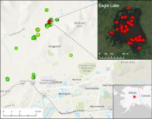
Location of 15 lakes surveyed for methane ebullition hotspots (green points) north of Fairbanks, AK, on October 8, 2014. Inset shows detail of Eagle Lake with locations of 43 hotspots (red points) detected by openings in lake ice.
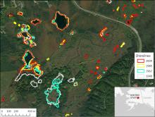
Shorelines of lakes northwest of Fairbanks, AK, over a 60 year period mapped from aerial photographs and satellite imagery. Notice the shoreline shift.