Body
Estimates of seasonal subsidence, ALT, vertical soil moisture profile, and uncertainties at a 30-m resolution for 28 sites across the ABoVE domain are now available.

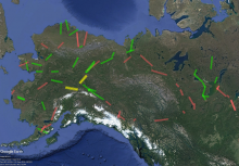
Sites in Version 2 of the Permafrost Dynamics Observatory Project product. Green = data delivered in Version 2. Red = not delivered in Version 2 but will be delivered in future version. Yellow = not processed due to only L-band data being available.
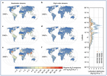
Riverine N2O emission estimates from headwater streams (a, c, and e) and high-order rivers (b, d, and f) for the 1900s, 1960s, and 2000s. The right panel shows the latitudinal distribution of riverine N2O emissions with the uncertainty range as the standard deviation (shaded areas).
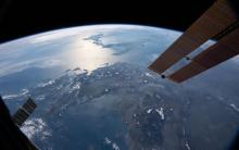
Data from the GEDI instrument on the International Space Station can help answer questions about Earth’s biomes and ecosystem impacts on the carbon cycle and climate. Credit: NASA

Introduction to Population Grids and their Integration with Remote Sensing Data for Sustainable Development and Disaster Mgmt. Two -part series, March 30 and April 6, 2021.
The North American Carbon Program (NACP) is a multidisciplinary research program designed to improve understanding of North America's carbon sources, sinks, and stocks.
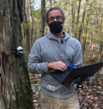
Dr. Anthony Walker installing an automated dendrometer on a Shagbark Hickory at ORNL. These devices take high frequency measurements of stem shrink and swell, providing data on wood growth and water transport through the tree. Credit: Dr. Jeff Warren.
Logo of the Ecological Forecasting Initiative.
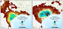
A regional view of Daymet V4 daily total precipitation over 2 days during the time period that Hurricane Harvey made landfall in August of 2017.

Dr. Peter Thornton studies the interactions of land ecosystems with other components of the Earth's climate system including biogeochemical and physical land-atmosphere feedbacks, and interactions with human systems.
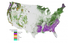
North American Forest Dynamics (NAFD) attribution type layer illustrating the type of change event where all events from 1986-2010 were combined. Source: Schleeweis et al. (2020) https://doi.org/10.3334/ORNLDAAC/1799