Body
High-resolution climate data inputs are now available for 11 states in the western U.S.

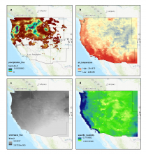
Four variables for the same 3-hour timestep, December 8, 2015, 12:00 AM to 3:00 AM, a) precipitation flux (kg m-2 s-1) b) air temperature (K) c) shortwave radiation flux (W m-2) d) specific humidity. Source: western_USA_precipitation_3hr_2015-12.nc4
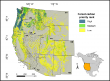
Forested land in the western conterminous United States classified by priority for preservation to mitigate climate change, based on the spatial co-occurrence of vulnerability to drought and fire and potential carbon sequestration. Source: Buotte et al. 2020
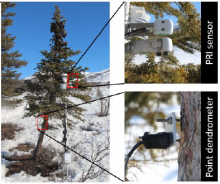
A white spruce tree is instrumented with a hemispherical and field-stop photochemical reflectance index (PRI) sensor and point dendrometer at a northern treeline site along the Dalton Highway, Brooks Range, Alaska. Source: Eitel et al., 2020
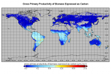
Global monthly gross primary productivity (GPP) of biomass for December 2016.
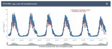
Level 4 SMAP Net Ecosystem Exchange (SPL4CMDL) Global daily 9km Gross Primary Productivity (GPP) mean subset for the Colorado Slate River Crested Butte site as graphed from the Fixed Sites Subsets Tool.
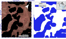
Example of Color-infrared imagery shown alongside the corresponding semi-automated open water classification at Old Crow Flats, Alaska.
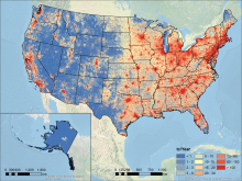
Vulcan v3.0 FFCO2 annual total emissions (tC/km2/year) for the United States in 2011 at a 1 km resolution. Source: Figure 3(a) in Gurney et al., 2020.
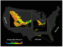
Example of average daily gross primary production (GPP) per m2 at 250 m resolution shown for wetlands in the North and South Ten Thousand Islands in the Florida Everglades. Mapped values are an average of all 16-day periods from 2000-2019. Source: Feagin et al., 2020.
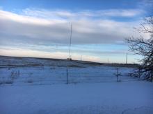
The communication tower at the Wessington, South Dakota site. This site was instrumented from January of 2017 to September of 2019.
Level 1 atmospheric greenhouse gas concentrations are available for towers across the central and eastern USA.
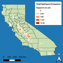
The sum of manure management and enteric fermentation methane emissions (in gigagrams per year) from dairy farms in California.
A new dataset from the North American Carbon Program (NACP) quantifies methane emissions from dairies across California.