Body
Gridded estimates of aboveground biomass (AGB) for live dry woody vegetation density between the years 2003 to 2016.

Pantropical aboveground biomass density change from 2003 to 2016. Data have been aggregated to 5 km resolution for illustration.
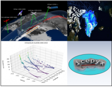
Laser Altimetry Datasets from NASA's ICESAT, IceBridge, and ICESat-2 missions are harmonized with Python tools to understand the evolution of land and sea ice.
Delta-X is a 5-year NASA Earth Venture Suborbital-3 mission to study the subsidence and growth of the Mississippi River Delta in the United States.
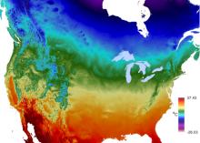
Average maximum temperature for a 24-hour period over an annual period.
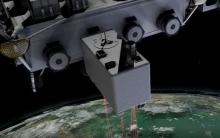
The GEDI instrument onboard the ISS uses three lasers split into eight tracks that fire 242 times per second illuminating a 25-meter footprint of the Earth's surface.
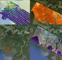
Collage of dataset airborne imagery from AirSWOT, UAVSAR and the ASO lidar instrument provide examination of water level elevation estimates and changes.
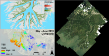
Pre-DeltaX image highlights: AVIRIS-NG/UAVSAR Biomass (upper left), AVIRIS-NG Total Suspended Solids (lower left), and AVIRIS-NG Surface Reflectance (right).
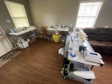
The Channel Team's water filtering lab inside a local cabin. The team will process 800 liters of water to extract as little as ~100mg of material found in a liter of Mississippi water.
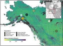
Spatial distribution of eight wolf study populations used in an assessment (from 2000-2017) of denning phenology in response to climate signals. The base map shows the day of the year representing the NDVI-derived start of the growing season in 2010.
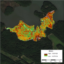
DEM of the Global Change Research Wetland (GCReW) site generated using the LEAN (LiDAR Elevation Correction with NDVI) method. LEAN uses ground measurements of elevation and NDVI in a multivariate linear regression model to estimate vertical bias.