Body
Estimates of methane (CH4) emissions from dairy farms in California for 2019.

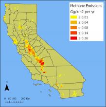
Total annual methane emissions in 2019 from dairy farms in California. These values represent the sum of emissions from enteric fermentation and manure management practices. Units are Gg per square kilometer per year. Source: total_CH4_CA_2019.tif
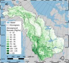
Spatial distribution of predicted aboveground biomass (AGB) density averaged over 1984-2014 for the ABoVE Core Study Domain. Ecoregions represent the EPA Level 2 Ecoregion boundaries. Source: Wang et al. (2021)
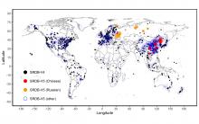
Locations of SRDB V5 observations combining pre-existing observations from V4 and new observations from Russian and Chinese literature, and literature from other languages (primarily English). Circle size represents sample size at each location.
An area of the Mississippi River Delta (Terrebonne and St. Mary Parishes, LA, USA) showing the largest present-day amount of tidal vegetation biomass in the conterminous US. (Source Louisiana_biomass_2015.tif).
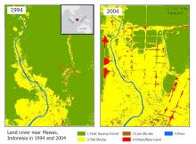
Land cover maps at 30 m resolution across Mawas, Central Kalimantan, Indonesia in 1994 (left) and 2004 (right).
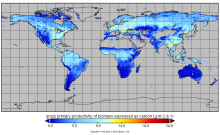
Gross primary production from FluxSat v2.0 expressed as carbon (g m-2 d-1) for July 1st, 2019.
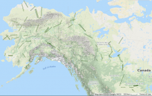
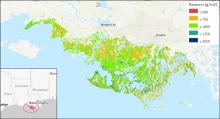
UAVSAR P-band SAR radar swaths over study sites across Alaska, USA, and western Canada for the 2017 ABoVE campaign.
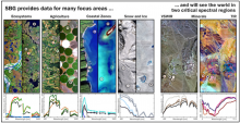
SBG Science and Applications Objectives Studies aim to compile the driving SBG requirements for all Designated Observable science and application objectives and to develop the SBG Science and Applications Traceability Matrix (image credit: NASA JPL).
Upcoming NASA Surface Biology & Geology (SBG) community webinar on 15 June 2021 at 1:00 PM Eastern Time.
PACE is an upcoming NASA hyperspectral mission focused on the aquatic environment.
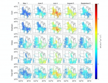
Examples of spatial patterns of reconstructed SIF at 4 km resolution. Only pixels with a fraction of the specific vegetation type larger than 0.1 are shown. For Total SIF, only pixels with a fraction of corn, soybean, grass/pasture, and forest larger than 0.8 are displayed.