Body
Synthetic Aperture Radar (SAR) was used to estimate methane ebullition flux for thousands of lakes in five regions across Alaska.

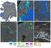
SAR-based lake ebullition maps. Panel a shows Alaska study regions with SAR footprints outlined in yellow. Subsequent panels show SAR-based CH4 ebullition maps for b) Barrow Peninsula, c) Atqasuk, d) Toolik, e) northern Seward Peninsula, and f) Fairbanks. Study lakes with field-based measurements are outlined (b,c) or boxed (d,e,f) in white. Orange boxes in panel f indicate anthropogenic study lakes.
Synthetic Aperture Radar (SAR) was used to estimate methane ebullition flux for thousands of lakes in five regions across Alaska.
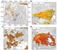
Spatial estimates of total carbon combustion at 30 m resolution across the 2015 fire perimeters in Saskatchewan (a) and sampled fires (b, c, d). The spatial extents of sampled fires are shown as blue rectangles in (a).
A new Arctic-Boreal Vulnerability Experiment (ABoVE) provides spatial estimates of carbon combustion and uncertainty on a 30 m grid.
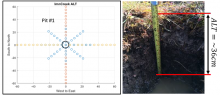
Site sampling plan used for characterizing active layer soils (left). Axes are in meters. At Imnavait Creek, active layer thickness (ALT) was measured on transects intersecting a central soil pit. Soil dielectric properties, in situ moisture and temperature profiles were measured, and soil samples were collected for analyses from the soil pit (right).
Active layer thickness, soil dielectric profiles, and soil physical properties are key variables for understanding the Arctic permafrost layer.
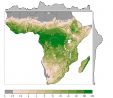
Estimates of woody biomass (tree and shrubs) at 1-km resolution in megagrams per hectare (Mg ha-1). Biomass was estimated from canopy cover, canopy height, and tree allometry. Source: C.W. Ross
Estimates of woody cover and biomass across sub-Saharan Africa were derived from observations, tree allometry equations, and remote-sensing products.
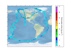
Particulate iodine measured along flight paths in ATom1 and ATom2. Image by J.L. Jimenez
Reanalysis of initial High-Resolution Aerosol Mass Spectrometer measurements of global oceanic coverage of particulate iodine are now available.
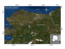
Sixteen measurement sites located across interior Alaska, USA, and at one site in Yukon, Canada. Sites C17K, C26K, E23, F17, H31, and I17 are collocated with the seismic stations.
New soil temperature profile measurements collected at USArray stations are available from the Arctic-Boreal Vulnerability Experiment (ABoVE).
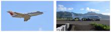
Left: The DLR Falcon used for the SALTRACE 2013 and the A-LIFE 2017 campaigns. Right: The NASA DC-8 aircraft used during the ATom missions sitting at the Pago Pago International Airport, American Samoa.
A new dataset from the Atmospheric Tomography Mission (ATom) compares airflow and aerosol particles.
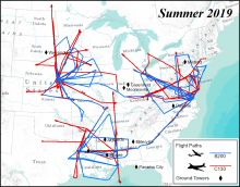
ACT-America 2019 summer airborne campaign showing the flight paths for the two aircrafts and location of ground towers. Flights were concentrated on three study domains: northeast, south-central, and midwest regions of the United States.
A new version of merged in situ atmospheric trace gases and flask data from the Atmospheric Carbon and Transport-America project is now available.
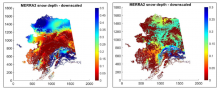
Downscaled MERRA-2 snow depth (in meters) data. Images show snow depth for two time periods: spring snow melt for 23-30 April, 2007 (left) and during early snow accumulation for 30 September-7 October, 2007 (right).
One kilometer resolution, cloud-free snow cover extent and snow depth data are available for Alaska from 2001 to 2017.
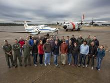
The ACT-America team on the tarmac with the NASA Langley Beechcraft B-200 King Air and NASA GSFC C-130-H Hercules aircraft in Shreveport, LA.
A new version of meteorological and aircraft navigational data is available from the Atmospheric Carbon and Transport-America project.