Body
New data from the Carbon Monitoring System (CMS) offers insights into how environmental factors affect the dynamics of leaching.

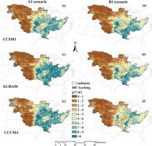
Spatial distribution of mean dissolved inorganic carbon (DIC) leaching (g c/m2/yr) in the 2090s estimated by S(ALL) simulation experiment (including future climate, elevated CO2, and land use changes). Climate change scenarios were derived from three climate models named CCSM3 (panels a and b), ECHAM (c and d), and CCCMA (e and f) under high (A2) and low (B1) emission scenarios, respectively.
New data from the Carbon Monitoring System (CMS) offers insights into how environmental factors affect the dynamics of leaching.

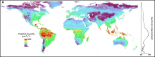
A global map of predicted annual soil respiration (Rs) at 1 km spatial resolution created by applying the QRF model to gridded covariates. Right is a plot of the latitudinal mean predicted annual Rs.
A machine learning approach was used to derive the predicted annual soil respiration and uncertainty at a 1 km spatial resolution.

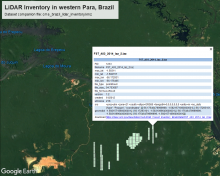
Bounding boxes for LiDAR tiles from surveys over western Para, Brazil, are depicted in Google Earth from the KMZ companion file. Each feature in the KMZ provides key metadata about the corresponding tile.
LiDAR surveys over forest research sites across the Amazon rainforest in Brazil are available.

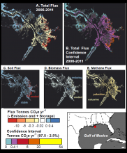
Estimated CO2e fluxes and confidence interval ranges for the Mississippi River outlet in Louisiana, United States. This area contains palustrine and estuarine wetlands, and includes stable wetlands, wetland gains and loss events from 2006 to 2011. A: Total flux from 2006 to 2011. B. Uncertainty, as represented by confidence interval range (0.975 - 0.025 quantile distributions of the results of the Monte Carlo Analysis). C-E. The relative contributions of soil, biomass, and methane to the total flux (A).
A new dataset provides maps of surface elevation, land cover, biomass, and estimated coastal wetland carbon fluxes.

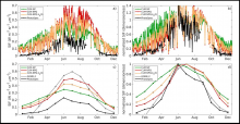
Simulated and observed seasonal patterns of canopy SIF (740 nm) for (a, c) absolute SIF and (b, d) normalized canopy SIF for CLM simulation year 2010. Both a satellite SIF product (GOME-2) and the PhotoSpec measurements are included for comparison.
Three related datasets from the Carbon Monitoring System (CMS) program describe year-round photosynthetic activity in a conifer forest.

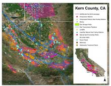
Example of AVIRIS-NG flight lines over the southern San Joaquin Valley, Kern County, CA, in Fall 2016 and the Vista-CA potential methane emitting facilities and infrastructure for the three primary sectors (energy, agriculture, and waste).
Maps of methane plumes were derived from Next-Generation Airborne Visible Infrared Imaging Spectrometer (AVIRIS-NG) flights over California.

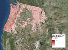
Forest aboveground biomass in megagrams per hectare for the year 2016.
Annual maps of aboveground biomass are available for forests in Washington, Oregon, Idaho, and western Montana, USA.

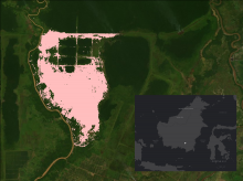
The area burned in 1997 and 1998 in the Mawas area, Central Kalimantan, Indonesia is shown in pink. The inset with white dot shows the location of Mawas study site on the Island of Borneo.
Maps of annual burned area from 1997 to 2015 show the extent of fires in the Mawas region of Central Kalimantan.

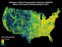
Map of DARTE on-road CO2 emissions for the conterminous United States for the year 2017.
The updated DARTE dataset provides high-resolution, annual, on-road CO2 emissions for the conterminous United States.

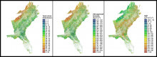
Maps of the number of years since the most recent disturbance, aboveground biomass, and net ecosystem productivity in the year 2010, for forests of the Southeastern USA.
A new Carbon Monitoring System dataset used a carbon cycle process model and historic data to estimate aboveground woody biomass and net ecosystem productivity over time.
