Body
NASA's Atmospheric Tomography (ATom) campaign collected whole air samples and measurements of formaldehyde during round-the-world flights.

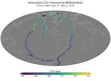
Measurements of atmospheric carbon dioxide concentration from flasks collected by the Medusa system during ATom-4 flights in 2018.
NASA's Atmospheric Tomography (ATom) campaign collected whole air samples and measurements of formaldehyde during round-the-world flights.

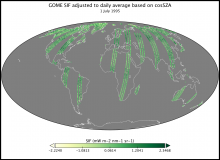
Solar-Induced Fluorescence derived along ERS-2 GOME orbital tracks on 1 July 1995.
Global estimates of solar-induced fluorescence (SIF) of chlorophyll from 1995 to 2003 are now available.

See you at AGU, December 9-13 in San Francisco.
Several ORNL DAAC staff members will be attending the American Geophysical Union Meeting December 9-13, 2019, in San Fransisco, CA.
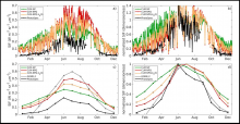
Simulated and observed seasonal patterns of canopy SIF (740 nm) for (a, c) absolute SIF and (b, d) normalized canopy SIF for CLM simulation year 2010. Both a satellite SIF product (GOME-2) and the PhotoSpec measurements are included for comparison.
Three related datasets from the Carbon Monitoring System (CMS) program describe year-round photosynthetic activity in a conifer forest.

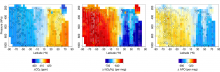
Example cross-sections of CO2, O2, and APO (O2 + 1.1 * CO2) measured by AO2 (interpolated flight track data) and the Medusa flask sampler (filled circles) during the Pacific southbound flights of ATom-4 in April and May 2018.
Data collected by the Airborne Oxygen Instrument (AO2) during the Atmospheric Tomography (ATom) airborne campaigns are now available.

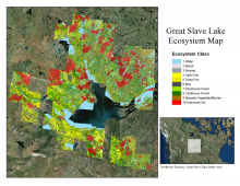
Ecosystem map for the Great Slave Lake area, Northwest Territories, Canada, for the period 1997-2011.
ABoVE researchers compiled a map of ecosystem states prior to the 2014 & 2015 fires in the Northwest Territories, Canada.

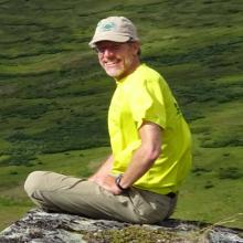
Dr. Peter Thornton leads the Modeling and Scale Integration Science Team for the Next-Generation Ecosystem Experiments (NGEE) Arctic project.
The lead developer of Daymet is recognized as a highly cited author in 2019.

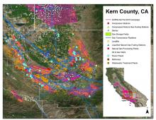
Example of AVIRIS-NG flight lines over the southern San Joaquin Valley, Kern County, CA, in Fall 2016 and the Vista-CA potential methane emitting facilities and infrastructure for the three primary sectors (energy, agriculture, and waste).
Maps of methane plumes were derived from Next-Generation Airborne Visible Infrared Imaging Spectrometer (AVIRIS-NG) flights over California.

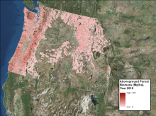
Forest aboveground biomass in megagrams per hectare for the year 2016.
Annual maps of aboveground biomass are available for forests in Washington, Oregon, Idaho, and western Montana, USA.

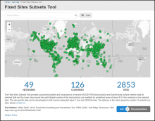
The Fixed Sites Subsets Tool provides customized, pre-processed, subsets and visualizations of land products for selected field and flux tower sites around the world.
Pre-processed subsets of VIIRS LST and SMAP NEE products are now available for many long-term research sites.
