Body
Pre-processed subsets of VIIRS LST and SMAP NEE products are now available for many long-term research sites.

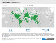
The Fixed Sites Subsets Tool provides customized, pre-processed, subsets and visualizations of land products for selected field and flux tower sites around the world.
Pre-processed subsets of VIIRS LST and SMAP NEE products are now available for many long-term research sites.

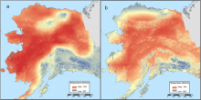
30-year annual average maximum temperature for Alaska at 60-m resolution for (a) the last glacial maximum period ~18,000 years ago and (b) the modern period 1975-2005.
A new dataset provides 30-year climate 'normals' for the last glacial maximum (~18,000 years ago) and the present day in Alaska.

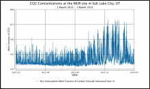
Carbon dioxide concentrations at the MUR site in Salt Lake City, Utah, show a pronounced seasonal pattern of higher CO2 in the winter months.
Hourly urban greenhouse gas measurements are available for cities in the CO2 Urban Synthesis and Analysis (CO2-USA) Data Synthesis Network.

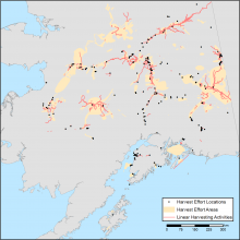
Combined map of subsistence resource use areas of Interior Alaskan communities with (1) points marking harvest effort locations, (2) polygons indicating harvest effort areas, and (3) lines indicating linear harvesting activity.
Maps of the search and harvest areas used by residents of Interior Alaska are available.

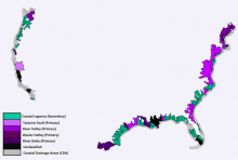
Estuaries classes used in the study: former river valley primary estuary, former glacier valley primary estuary, river delta primary estuary, tectonic structural primary estuary, coastal lagoon secondary estuary, and unclassified estuary.
Soil organic carbon (SOC) estimates and environmental data for US estuaries are available for the period 1972-2015.


The NASA DC-8 aircraft was used for the ATom missions.
Aerosol data collected during Atmospheric Tomography Mission (ATom) will inform on new particle formation occurrence in the tropics.


NASA's Earth Observing System Data and Information System (EOSDIS) is a key core capability in the Earth Science Data Systems (ESDS) Program.
Solicitations for the 2019 NASA EOSDIS Annual Customer Satisfaction Survey have been distributed by email.
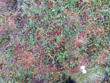
A plot photo (#0656) taken at the largest study area 'Toolik' at elevation 765.7 m. The small white object was included in many of the photos as a color reference. The photographer's boots are also often visible, in this photo they are to the lower left of the white object.
A new ABoVE dataset offers hundreds of ground-based vegetation photos which may serve as a reference for studies of climate and vegetation change in the area.

The Atmospheric Tomography (ATom) Mission is an Earth Venture Suborbital-2 mission to measure greenhouse gases and human-produced air pollution in remote areas.
Five new datasets from ATom provide measurements of greenhouse gases and human-produced air pollution from 2016 to 2018.
 Mission")
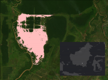
The area burned in 1997 and 1998 in the Mawas area, Central Kalimantan, Indonesia is shown in pink. The inset with white dot shows the location of Mawas study site on the Island of Borneo.
Maps of annual burned area from 1997 to 2015 show the extent of fires in the Mawas region of Central Kalimantan.
