Body
On November 1, 2022 the ORNL DAAC transitioned Daymet V4 distribution to a V4 Revision 1 (V4 R1) distribution.

ARSET - Disaster Assessment Using Synthetic Aperture Radar webinar banner.
The Claes Fornell International (CFI) Group has concluded feedback solicitation on behalf of NASA for EOSDIS DAACs to determine customer satisfaction in 2022.
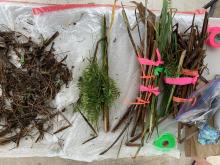
Aboveground vegetation sorted by species into biomass and necromass components.
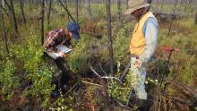
Researchers collecting data on vegetation and biophysical characteristics at a study site in Northwest Territories of Canada that was burned by wildfires in 2014-2015.
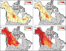
Total burned area (a), total carbon emissions (b), mean combustion (c), and mean burn depth (d) between 2001-2019 aggregated to a 70 km grid. Note that burned area (a) covers all of Alaska and Canada whereas all other metrics cover the ABoVE extended domain.
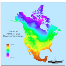
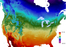
Maximum Temperature from Daymet Version 4 Monthly Latency: Daily Surface Weather Data on March 31, 2021 was produced in April of 2021.
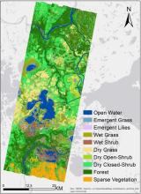
The wetland vegetation community classification for the Peace-Athabasca Delta, Alberta, Canada created from AVIRIS-NG derived features.
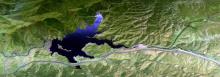
RGB composite MASTER image from data collected during the SARP campaign over Pyramid Lake, California, USA on 2009-07-24. Image derived from bands 12, 10, 9 spanning visible to near-infrared wavelengths.
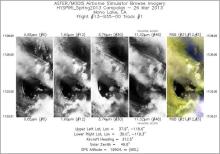
Single band images and an RGB composite image from flight track 1 acquired on 26 March 2013 over Mono Lake, California, U.S. Source: /MASTERL1B_1393500_01_20130326_1728_1733_V01.jpg from dataset MASTER: HyspIRI Airborne Campaign, California, Early Spring 2013.