Body
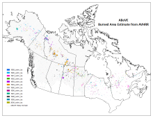
Vegetation species and other environmental and soil parameters are available from over 3400 plot locations within the NASA ABoVE study domain.

Vegetation, soil, and environmental data were collected from over 3400 plot locations in the ABoVE study area.
Vegetation species and other environmental and soil parameters are available from over 3400 plot locations within the NASA ABoVE study domain.

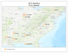
Map of the locations of ACT-America towers active in 2016.
Data from ACT-America provides atmospheric carbon measurements from nine towers in the Eastern US.

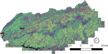
This overview map shows thirty unique vegetation canopy structure classes identified within the Great Smoky Mountain National Park in Tennessee and North Carolina, USA.
An updated dataset characterizes vegetation canopy structure in the Great Smoky Mountains National Park.

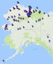
The ABoVE study domain showing cumulative annual burned areas derived from AVHRR for 1989 - 2000.
A long-term record of annual forest fire burned area and daily hotspots are provided in a new ABoVE dataset.


Global distribution of hydrologic soil groups at 250-m spatial resolution. Hydrologic soil groups A, B, C, and D correspond to low, moderately low, moderately high, and high runoff potential, respectively. Wet soils are assigned a dual HSG (e.g., HSG A/D) and have high runoff potential due to the presence of a water table within 60 cm of the surface. A less restrictive group can be assigned if these soils are drained (e.g., HSG-A).
High-resolution and globally consistent hydrologic soil groups are provided in a new dataset.

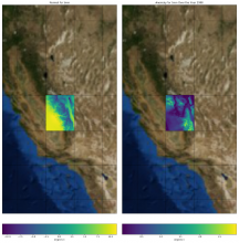
Climate anomaly (right panel) in minimum daily temperature for year 1990 compared to the long-term normal (left panel). The climate normal and anomaly were calculated for a single 2-degree tile from the Daymet dataset.
New Jupyter notebook tutorials show how to access and visualize Daymet climate data from within Python and how to calculate climate normals and anomalies.

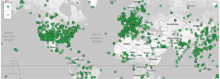
Pre-processed MODIS land products data at more than 2000 field and flux tower sites are available through the MODIS Collection 6 Fixed Sites Subsetting and Visualization Tool.
The ORNL DAAC offers pre-processed subsets of MODIS Collection 6 Land Products at more than 2000 field and flux tower sites around the world.

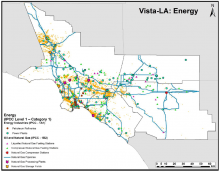
Locations for infrastructures associated with the energy industry with known or expected potential to emit CH4 in the South Coast Air Basin (SoCAB). Vista-LA includes a total of 33,614 features across 13 layers. From Carranza et al., 2017.
A new dataset from Vista-LA provides an inventory of potential methane emitting facilities in the greater Los Angeles urban area.

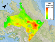
Fire Weather Index (FWI) for Interior Alaska on July 22, 2006. FWI is a numerical rating between 0 and 30 where higher values indicate a higher risk of wildfire.
New data from Alaska quantify the daily weather conditions and risk of wildfire from 2001 to 2010.
 for Interior Alaska")
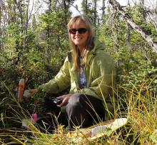
Dr. Laura Bourgeau-Chavez using a handheld water content reflectometer to measure soil moisture at a field site in Delta Junction, Alaska. Image courtesy of Dr. Bourgeau-Chavez.
Dr. Laura Bourgeau-Chavez uses NASA Earthdata for studying wetlands and wildfire.
