Body
GEDI L4A Footprint Level Aboveground Biomass Density, Version 1 released.

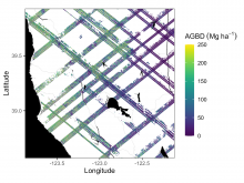
Example subset of aboveground biomass density (AGBD; Mg ha-1) predictions from the GEDI Level-4A footprint version 2.1 product over Northern California, USA, spanning April to July 2019. GEDI footprints are spaced 60m along track and 600m across-track.
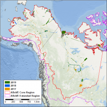
ABoVE flight paths of the AVIRIS-NG instrument during 2017, 2018 and 2019.
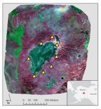
Color infrared image of Big Trail Lake in the Goldstream Creek Valley north of Fairbanks, Alaska. Ground control points (yellow triangles) surround the lake. Image was produced from NIR (red), red (green), and green (blue).
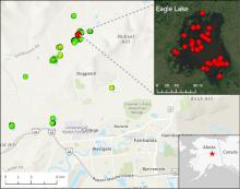
Location of 15 lakes surveyed for methane ebullition hotspots (green points) north of Fairbanks, AK, on October 8, 2014. Inset shows detail of Eagle Lake with locations of 43 hotspots (red points) detected by openings in lake ice.
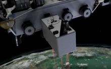
The GEDI instrument onboard the ISS uses three lasers split into eight tracks that fire 242 times per second illuminating a 25-meter footprint of the Earth's surface.
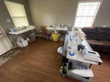
The Channel Team's water filtering lab inside a local cabin. The team will process 800 liters of water to extract as little as ~100mg of material found in a liter of Mississippi water.
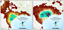
A regional view of Daymet V4 daily total precipitation over 2 days during the time period that Hurricane Harvey made landfall in August of 2017.
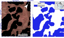
Example of Color-infrared imagery shown alongside the corresponding semi-automated open water classification at Old Crow Flats, Alaska.
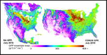
Mean gross primary productivity (GPP) for the conterminous US and North America in grams of carbon per unit area per month.
Modeled estimates of biogenic CO2 exchanges between land and atmosphere across portions of North America are available.
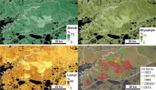
Vegetation point-intercept (VPI) any-hit cover metric data were combined with Landsat imagery to develop fractional maps of any-hit cover for four aggregated plant functional types (PFTs); shrubs bryophytes, lichen, and herbs for the upland tundra area of the Y-K Delta, Alaska. VPI data were collected from plots in areas burned in 1971, 1985, 2005, and 2015.
Ecological field data and maps of vegetation cover spanning gradients of fire history in upland tundra are available from the Arctic-Boreal Vulnerability Experiment (ABoVE).