Body
Version 2 of the dataset on satellite- and FLUXNET tower-derived data on daily gross primary production of global vegetation has been released.

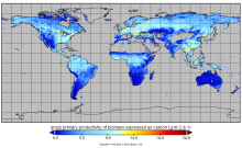
Gross primary production from FluxSat v2.0 expressed as carbon (g m-2 d-1) for July 1st, 2019.
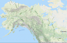
UAVSAR P-band SAR radar swaths over study sites across Alaska, USA, and western Canada for the 2017 ABoVE campaign.
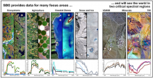
SBG Science and Applications Objectives Studies aim to compile the driving SBG requirements for all Designated Observable science and application objectives and to develop the SBG Science and Applications Traceability Matrix (image credit: NASA JPL).
Upcoming NASA Surface Biology & Geology (SBG) community webinar on 15 June 2021 at 1:00 PM Eastern Time.
PACE is an upcoming NASA hyperspectral mission focused on the aquatic environment.
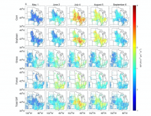
Examples of spatial patterns of reconstructed SIF at 4 km resolution. Only pixels with a fraction of the specific vegetation type larger than 0.1 are shown. For Total SIF, only pixels with a fraction of corn, soybean, grass/pasture, and forest larger than 0.8 are displayed.
Pantropical aboveground biomass density change from 2003 to 2016. Data have been aggregated to 5 km resolution for illustration.
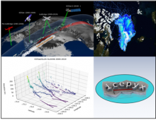
Laser Altimetry Datasets from NASA's ICESAT, IceBridge, and ICESat-2 missions are harmonized with Python tools to understand the evolution of land and sea ice.
Delta-X is a 5-year NASA Earth Venture Suborbital-3 mission to study the subsidence and growth of the Mississippi River Delta in the United States.
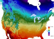
Average maximum temperature for a 24-hour period over an annual period.
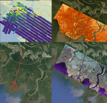
Collage of dataset airborne imagery from AirSWOT, UAVSAR and the ASO lidar instrument provide examination of water level elevation estimates and changes.