Body
Daily “blue sky” shortwave albedo data were derived from the MODIS bi-directional reflectance distribution function.

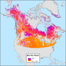
Daily mean shortwave blue sky albedo for February 28, 2000. Blue sky refers to albedo calculated under real-world conditions with a combination of both diffuse and direct lighting based on atmospheric and view-geometry conditions.
Daily “blue sky” shortwave albedo data were derived from the MODIS bi-directional reflectance distribution function.

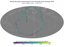
Dry-air mole fraction of methyl bromide measured in Programmable Flask Package samples taken during Atom-2 flights in January-February 2017.
Two new instrument datasets available from the Atmospheric Tomography Mission (ATom).


The UWG meets once per year to review the status of ORNL DAAC operations and to provide recommendations.
Joe Sexton, Michael Dietze, Nancy Glenn, and Lucy Hutyra will be rotating off the User Working Group this year.

GEDI data will help further refine our understanding of the carbon cycle and atmospheric concentrations of carbon dioxide (CO2).
Level 1 and 2 high-resolution, laser altimetry data from the Global Ecosystem Dynamics Investigation (GEDI) are now available from the LP DAAC.
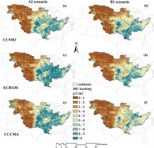
Spatial distribution of mean dissolved inorganic carbon (DIC) leaching (g c/m2/yr) in the 2090s estimated by S(ALL) simulation experiment (including future climate, elevated CO2, and land use changes). Climate change scenarios were derived from three climate models named CCSM3 (panels a and b), ECHAM (c and d), and CCCMA (e and f) under high (A2) and low (B1) emission scenarios, respectively.
New data from the Carbon Monitoring System (CMS) offers insights into how environmental factors affect the dynamics of leaching.

Peak greenness derived from the Normalized Difference Vegetation Index (NDVI) for the year 2010 in the ABoVE grid cell Bh07v07.
Maps of annual seasonality and greenness are now available from the Arctic-Boreal Vulnerability Experiment.

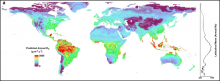
A global map of predicted annual soil respiration (Rs) at 1 km spatial resolution created by applying the QRF model to gridded covariates. Right is a plot of the latitudinal mean predicted annual Rs.
A machine learning approach was used to derive the predicted annual soil respiration and uncertainty at a 1 km spatial resolution.

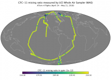
Mixing ratio of CFC-11 measured by Whole Air Sampler (WAS) during ATom-4 flights in April-May 2018.
The UC-Irvine Whole Air Sampler (WAS) instrument was used during the Atmospheric Tomography (ATom) mission.
, April-May 2018.")
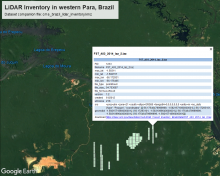
Bounding boxes for LiDAR tiles from surveys over western Para, Brazil, are depicted in Google Earth from the KMZ companion file. Each feature in the KMZ provides key metadata about the corresponding tile.
LiDAR surveys over forest research sites across the Amazon rainforest in Brazil are available.

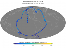
Measurements of atmospheric acetone concentration from samples collected by the Trace Organic Gas Analyzer (TOGA) during ATom-3 flights in 2017.
Concentrations of volatile organic compounds (VOCs), measured by the Trace Organic Gas Analyzer (TOGA), are available.
