Body
A new version of meteorological and aircraft navigational data is available from the Atmospheric Carbon and Transport-America project.

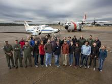
The ACT-America team on the tarmac with the NASA Langley Beechcraft B-200 King Air and NASA GSFC C-130-H Hercules aircraft in Shreveport, LA.
A new version of meteorological and aircraft navigational data is available from the Atmospheric Carbon and Transport-America project.
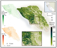
Estimated aboveground biomass (Mg/ha) for Sonoma County at 30 m spatial resolution with the 5th-95th percentile range and the standard deviation (SD) of per-pixel biomass estimates shown in the top left and bottom left, respectively.
A new dataset used a parametric modeling approach to estimate biomass from airborne LiDAR data and field measurements.
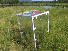
The custom-built chamber for measuring in situ trace gas fluxes from soil/vegetation and water surfaces. The chamber (~ 0.5 m3) provides adequate height to enclose emergent grasses and reeds.
A new dataset provides diffusive methane (CH4) fluxes of emergent and upland vegetation at two thermokarst lakes in Alaska.
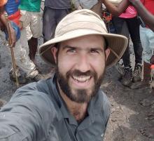
Dr. David Lagomasino uses satellite, airborne, drone, and ground measurements to identify areas of coastal resilience and vulnerability.
Dr. David Lagomasino uses NASA data to study how the Earth's landscape responds to changes caused by natural events and rapid urban expansion.
Unidata's THREDDS Data Server (TDS) is a web server that provides metadata and data access for scientific datasets, using a variety of remote data access protocols.
A bug has been fixed in the THREDDS Data Server (TDS) NetCDF Subsetting Service (NCSS) that may, in rare cases, have returned incorrect results.
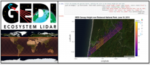
The Find and Use GEDI, You Will—Getting Started with Global Ecosystems Dynamics Investigation (GEDI) Lidar Data webinar will be held on Wednesday, June 24, from 2 to 3 PM EST.
The Land Processes (LP) DAAC will get you started with GEDI data on Wednesday, June 24.
Cover image of the 2017-2027 Decadal Survey, “Thriving on Our Changing Planet: A Decadal Strategy for Earth Observations from Space.”
The NASA Surface Topography and Vegetation (STV) Incubation Study will hold its first community workshop on July 9, 2020.
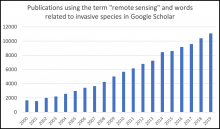
Searching for the term remote sensing and words related to invasive species (invasive, nonnative, exotic, or nonindigenous) in Google Scholar reveals an increasing number of publications each year using these terms.
A new Earthdata article describes how researchers are using remote sensing to map invasive species.
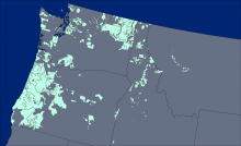
The locations of the 176 lidar collection areas (light green polygons) acquired between 2002 and 2016.
Aboveground biomass was derived from forest inventory data and lidar imagery.
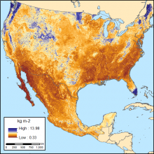
Soil organic carbon (SOC) for 0-30 cm topsoil layer in kg SOC/m2 at 250-m resolution across Mexico and the conterminous USA (CONUS) for the period 1991-2010.
Two sets of estimated soil organic carbon and uncertainties are available at a 250 m resolution.